Date
Overview
Image

Public Domain via Wikimedia Commons.
For a downloadable PDF of this lesson, click below:
Document
Lesson_Spatial Ecology_Land Sparing Sharing.pdf
(625.92 KB)
Spatial ecology is the study of how the size of a habitat and its diversity, or heterogeneity, affect the existence and distribution of species, their interactions, and their access to resources. In addition to the size and type of a habitat, its spatial arrangement also matters greatly—is the habitat in one large parcel with minimal edges, or is it a series of smaller fragments, patches, or mosaics with extensive edge effects? In the socio-environmental realm, spatial ecology sheds light on how ecosystem services like fresh air, water, and shade cover affect human groups that dwell in proximity to natural habitats. While human activities often degrade adjacent natural habitats, spatial ecologists also seek to understand how access to green spaces enhances health and well-being among human groups, and how the spatial arrangement of natural habitats influences epidemiological outcomes. In this lesson, we'll consider two models of urban green space, land sparing and land sharing, for the evidence of their relative contribution to improved human well-being in urban areas.
Assumed Prior Knowledge
Appropriate for undergraduate and graduate students who seek to enhance their interdisciplinary skill in assessing the socio-environmental interface of urban park land. It will be useful to have a basic background in land sharing versus land sparing.
Learning Objectives
- Learn analytical methods in spatial ecology that help scientists use quantitative approaches to evaluate ecosystem services in urban areas.
- Comprehend and assess the ongoing debate about land sparing versus land sharing.
- Compare and evaluate alternative land uses for their public health and ecosystem service effects and select among a set of choices to achieve optimal land-use benefits.
- Critically assess analytical methods in spatial ecology to look for bias in results, particularly as relates to social class and habitat quality.
Key Terms/Concepts
spatial ecology; urban land use; urban food production; land sharing; land sparing; ecosystem services; epidemiology; air pollution; asthma; environmental justice; intersectionality; slow violence
The “Hook” (suggestions for quickly engaging students)
-
Fruitful Cities, Healthy People?
Image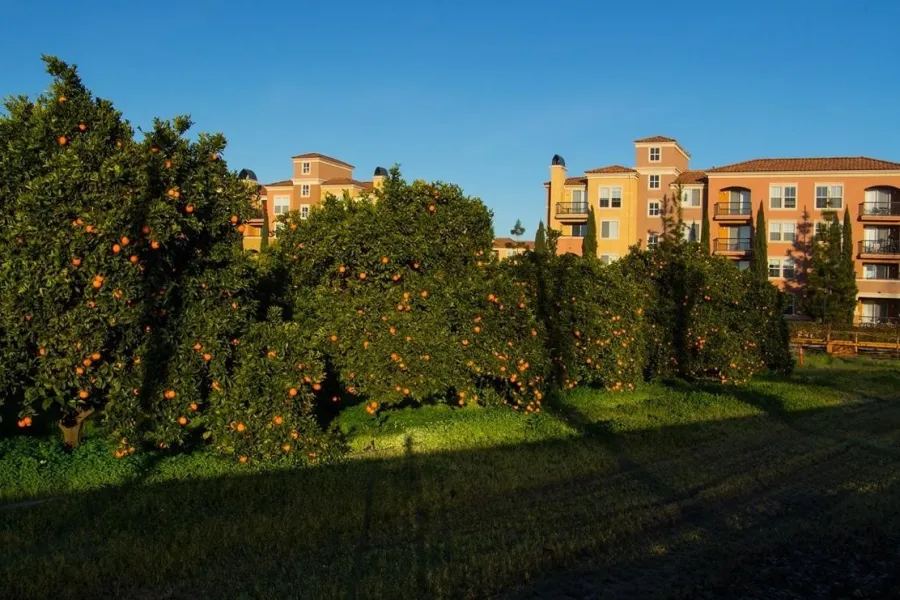
The last of the orchards and groves in San Jose. This orange grove brightens the morning for commuters to Silicon Valley. Unaltered photo by Don McCullough, Wikimedia
Have students view this image of an urban orange grove. Imagine living in the apartment blocks around it. In small groups of 3–4, in a 5-minute lightning session, have them list pros and cons of proximity to this orchard land use versus: 1. More apartment buildings like those seen, and 2. An urban park filled with diverse trees and wildlife habitat. After 5 minutes, each group should have a list of potential advantages and disadvantages of proximity to three kinds of land use: urban infrastructure (e.g., residential buildings), urban agronomy (e.g., orchard), and urban parks (e.g., biodiversity and wildlife habitat). They might consider economics, culture, food production, gentrification, and access to green space. Take a vote: What’s the land use choice for them? What additional information would help them decide?
Teaching Assignments
-
Land Sparing versus Land Sharing: Spatial Ecology’s Insights (Two 75-minute classes)
Part 1: Have the students read a brief summary of the Land Sharing versus Land Sparing debate, and the Abstract and Conclusion (below) from Cirino et al.’s 2022 “Balanced spatial distribution of green areas creates healthier urban landscapes”
Document- Review the basic conclusion of this study: land use configuration does correlate with epidemiological outcomes in respiratory and cardiovascular disease, with land sharing providing greater benefits to humans presumably because more people have access to interspersed tree cover in less densely developed neighborhoods. Also note the weak correlation between land sparing and upper respiratory infection rates.
- If we accept Cirino et al’s conclusions, the implications of spatial ecology and city planning are enormous. Divide the class into four groups that each prioritize a different aim:
- human health (mental and physical)
- wildlife habitat (plants and animals)
- urban food production
- climate change adaptation and carbon sequestration
- Have each group spend a 10-minute brainstorming session listing the potential effects of land sharing versus land sparing for their particular interest. For example, the “urban food production” group would probably favor a land sharing regimen with urban farms and gardens abundant in private yards and borderline spaces along roads and waterways. Though they might disfavor a land sparing strategy, they should still list ways to achieve food production in cities with dense human development abutting wild parks; this might include vertical gardens and green roofs.
- Have each group nominate a spokesperson to represent their arguments and conclusions. Give each presenter ~5 minutes to present the group’s view and field questions from peers. After this ~20 minute roundtable of the four groups, give each group an additional ~10 minutes to discuss and modify their original ideas.
- Finish the session by having each group propose a general urban planning regimen that places their interest as the top priority, but ideally does not ignore the other interests. Each regimen should include a ratio of hardscape (buildings, parking lots) : land sharing uses (sylvan yards and public areas : land sparing uses (parks and protected wilderness areas). For example, the “wildlife habitat” group might propose a 40:10:50 ratio, showing their high preference for undisturbed habitat in a land sparing design. Each group should be aware of the benefits and costs of their prescription.
Part 2: As homework, have students convert their urban plan into a neighborhood diagram (digital or hand drawn), sketched to the proper ratios with labels for each land use type. How do elements of spatial ecology such as habitat density and distribution inform their best ideas?
Part 3: In the next class, students should be reassigned to new groups of four, regardless of their area of interest in the previous session. New group dynamics are welcome. Post the diagrams and have each new group evaluate three peer plans using quantitative measures (20–30 min).
-
Groups should give a 1–5 score on each of the four priorities outlined in part 1 of this lesson. 1 indicates the total absence of this service, and 5 indicates excellent provision of the service. In many cases, a higher score in one service may cause a lower score in others, but this is not necessarily the case in synergetic land uses, such as Wildlife Habitat that also benefits Human Health.
-
Quantify a total score that results. Four is the lowest possible, and twenty is the highest possible. Though there will be some subjectivity in groups' interpretation of value and points awarded for services, these scores across multiple group evaluations should clarify the best plans overall, and the relative strengths in each service category.
- Post the top 3 diagrams according to their scores. Hopefully, some diagrams will represent a broad cross-section of services (generalist), while some diagrams will represent just one service’s top score (specialist). Discuss how scores differ based on general service provision (mostly 3-4 scores) versus specialization (1/5 scores). Students may wish to explore how generalist plans follow a land sharing ethos, whereas specialist plans more often resemble land sparing.
- Attempt a synthesis across the “winning” diagrams. What characteristics do they have in common, and how does that relate to spatial ecology? How do their priorities and approaches differ; do these contrasts help to show the hard choices facing urban planners? Are there common trends or similarities that coalesce to reveal universal benefits? Have the class vote on one final winning diagram. In a lightning team composition session, type out the class’s narrative on why this plan was voted best.
-
-
Evaluating Methods in Spatial Ecology: Cirino’s Study (one 50-75 min class)
This more advanced lesson requires learners to act as peer reviewers of the science itself. They will evaluate the study methods and assumptions, and point out possible biases in the results. Cirino et al. 2022 is a peer-reviewed study that uses the latest epidemiological and ArcGIS analysis methods. While this lesson is not intended to undermine the science, it is important for learners to know how to act as skeptical peer reviewers and propose fixes to scientific analytical methods.
- Participants should read the entire Cirino et al. study, paying special attention to how the researchers use public health data and spatial analysis of land uses. Then divide them into groups of 3-4 for discussion.
- Begin with the public health data from the Universal Health System.
- What source do they use, and how might that source not be a representative sample across Brazilian socio-economic groups?
- If it’s not a representative sample, how might that seed bias in the results? Have them think not only of who is sampled and who is not, but also how lower socio-economic groups may have a harder time accessing healthcare even when it is state-provided.
- Now have the small groups evaluate the spatial analysis of land uses.
- Specifically, they should evaluate how the simplification to three categories, Forests, Isolated Trees, and Open Vegetation, may be necessary for the statistical analysis of data, but may misrepresent actual land configurations.
- Note the study’s admission that, “Consequently, in this study, land sharing and sparing indices consider only the spatial distribution of arboreal vegetation, and not all green areas in the city” (bottom of Section 2.5 in paper). What are some qualitative differences between forested areas and anything else green, such as lawns, gardens, small orchards, and bushlands? Do the latter have public health or ecosystem benefits that ought to be valued?
- Have learners draft a brief peer review response that engages with these issues in the analytical methods.
- Do any participants have suggestions for what the researchers could have done differently within existing methods?
- Or, have Cirino et al. maximized the current methods, and does the study need to acknowledge possible blind spots and biases in these analytical limitations?
- Have the whole class compare peer review critiques and compile a list of responses. Conclude with the final question: Can these results from Sao Paolo Brazil be seen as representative across global cities in terms of the benefits of land sharing versus land sparing?
- Have the whole group brainstorm differences in approach to epidemiology if the city were New York, Amsterdam, Nairobi, Lagos, or Beijing.
- Then do the same for spatial analysis, noting that several of these cities are not in forested ecosystems like the Amazon, but are naturally more watery or grassland. How might values of land sharing/sparing differ among different global ecosystems?
Background Information for the Instructor
-
Reframing landscape fragmentation’s effects on ecosystem services by Mitchell et al.
Landscape structure and fragmentation have important effects on ecosystem services, with a common assumption being that fragmentation reduces service provision. This is based on fragmentation’s expected effects on ecosystem service supply, but ignores how fragmentation influences the flow of services to people. Here we develop a new conceptual framework that explicitly considers the links between landscape fragmentation, the supply of services, and the flow of services to people. We argue that fragmentation’s effects on ecosystem service flow can be positive or negative, and use our framework to construct testable hypotheses about the effects of fragmentation on final ecosystem service provision. Empirical efforts to apply and test this framework are critical to improving landscape management for multiple ecosystem services.
-
Introduction to Spatial Ecology and Its Relevance for Conservation by Robert J. Fletcher
How space directly and indirectly affects biodiversity and ecosystem functioning is the focus of several subdisciplines in the life sciences. All of these subdisciplines share concepts and analytical methods that stem from the field of spatial ecology. Spatial ecology focuses on the study and modeling of the role(s) of space on ecological processes that in turn affects ecological patterns. Our goal is to introduce why space is important for ecology and conservation, and how various components of space can inform ecological processes and be modeled.
-
What happens if you cut down all of a city’s trees? by Stefan Al
Explore what makes trees a vital part of cities, and how urban spaces throughout history have embraced the importance of trees. A TED-Ed talk.
Share