Date
Image
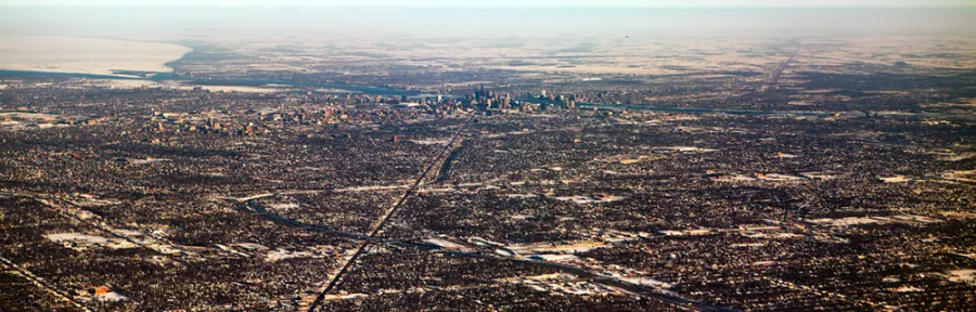
Annapolis, Md — From a bird’s eye view, it might be difficult to distinguish between the similar urban patterns of Baltimore and Detroit. But a new study by Kristina Hopkins, postdoctoral fellow at the National Socio-Environmental Synthesis Center (SESYNC), cautions against judging a city—or more specifically, its stream flow—by just its streets.
Hopkins studies how urban development leads to declines in water quality, and the ways in which cities can sustainably manage their stormwater to mitigate some of those consequences. In this latest research, she and her colleagues demonstrate how the natural landscape features found below a city’s pavement influence rain and snowmelt runoff—and, ultimately, stream health. They show that an urban area’s glacial past may provide it with physical characteristics that can buffer against some of the negative impacts associated with urbanization.
The findings could have significant implications for how practitioners design and manage stormwater systems by emphasizing the need to understand what makes a city geologically unique.
“Just because cities may look the same doesn’t mean they function the same, from a hydrologic perspective,” Hopkins said. “This research supports the idea that if cities are going to build and maintain their stormwater infrastructure to lessen the impacts of urbanization on aquatic ecosystem health, they need to think about what locally is impacting that relationship.”
A scientific paper based on the research, which Hopkins led while working on her doctoral degree at the University of Pittsburgh, was published online February 9 in the journal Environmental Science & Technology.
Using geospatial data and stream flow records, the researchers compared the degree of urban land coverage within and between nine U.S. cities (Atlanta, GA; Baltimore, MD; Boston, MA; Detroit, MI; Raleigh, NC; St. Paul, MN; Pittsburgh, PA; Phoenix, AZ; and Portland, OR) to changes in stream flow events. Despite the cities having similar degrees of developed land, impervious surface, and sewer service, the researchers found notable differences in hydrologic responses to these apparently uniform urban patterns.
The explanation for these differences, the researchers say, may be in what lies beneath the cities’ pavement. High stream flows were less frequent and less severe in cities that were historically influenced by glaciers (Boston, Detroit, St. Paul, and Portland). These cities also tended to have level topography, more lakes, and more permeable soil, all of which naturally slow down the movement of runoff through the landscape.
The role of natural physical geography adds a new dimension to understanding how urban development impacts watershed health. Hopkins and her co-authors say it’s a relationship that’s becoming increasingly critical.
“Given urban growth projections, landscape alterations during city expansion will continue to be one of the primary drivers of global environmental change. Increased impervious cover following urbanization has led to a consistent decline in the quality of health of urban aquatic ecosystems, termed the urban stream syndrome,” the researchers wrote.
As urban areas grow, they cover natural landscapes with pavements including driveways and parking lots. These hard surfaces prevent water from naturally soaking into the ground and instead generate more runoff to nearby streams. Because runoff carries with it pollutants such as oil, chemicals, and fertilizers, the amount of runoff has serious implications for water quality in those streams.
But presuming that urbanization uniformly impacts stream flow and pollution overlooks the significance of natural features. A city’s topography and soil, which may add or diminish the water-storage capacity of the landscape, are major factors in stream flow response to urbanization.
The researchers hope that their findings can inform practitioners working at the intersection of urban development and watershed health. Hopkins explains that the motivation to take note is economic: designing and managing water infrastructure isn’t a one-size-fits-all investment.
“While installing a rain garden is generally a good idea whether you’re in Baltimore or Boston, how you design it will vary depending on where you are,” she said. “You need to know something about the topography and soils to ensure your design will be effective within that landscape.”
Daniel Bain, co-author of the paper and Assistant Professor in the Department of Geology & Planetary Science at the University of Pittsburgh, agrees.
“There’s probably too much optimism that there’s one, easily-applicable framework to address declines in stream health associated with urbanization,” he said. “A single set of practices isn’t realistic because of the unique geophysical histories and characteristics of these urban systems.”
Hopkins’s and Bain’s co-authors included Nathaniel Morse of the University of New Hampshire, Neil Bettez of the Cary Institute of Ecosystem Studies, Nancy Grimm of Arizona State University, Jennifer Morse of Portland State University, Monica Palta of Arizona State University, William Shuster of the U.S. Environmental Protection Agency, Anika Bratt of the University of Minnesota, and Amanda Suchy of Arizona State University.
Media Contact
Melissa Andreychek
mandreychek@sesync.org
(410) 919-4990
@SESYNC
The National Socio-Environmental Synthesis Center, funded through an award to the University of Maryland from the National Science Foundation, is a research center dedicated to accelerating scientific discovery at the interface of human and ecological systems.
Above photo: Aerial view of Detroit, courtesy Sean Frego via Flickr/Creative Commons
Share